Finding our way around the Moon is likely to be a tricky proposition. Unlike Earth, there are no roads, signs, or common landmarks on the lunar surface — at least not yet. Until that happens, we may want to rely on an artificially intelligent system that’s currently in development.
As NASA prepares to land astronauts on the Moon as part of its Artemis program, the space agency is seeking to ensure that crews will be able to easily navigate across the lunar surface.
Alvin Yew, a research engineer at NASA’s Goddard Space Flight Centre in Greenbelt, Maryland, is developing an AI navigation system for future Moon explorers. “For safety and science geotagging, it’s important for explorers to know exactly where they are as they explore the lunar landscape,” Yew said in a statement. “Equipping an onboard device with a local map would support any mission, whether robotic or human.”
The NASA engineer is teaching an artificially intelligent system to navigate its way around the Moon using features across the lunar surface such as ridges, craters, and boulders. Yew used data from NASA’s Lunar Reconnaissance Orbiter, which has been orbiting the Moon since 2009. The orbiter is equipped with an instrument named LOLA, or Lunar Orbiter Laser Altimeter, which “measures slopes, lunar surface roughness, and generates high resolution topographic maps of the Moon,” according to NASA.
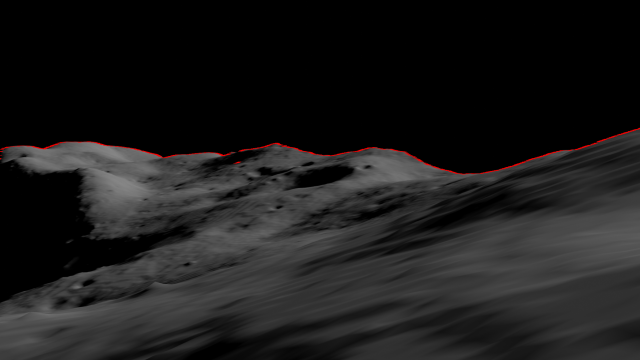
Using the data collected by LOLA, Yew is training the AI on how to “recreate features on the lunar horizon as they would appear to an explorer on the lunar surface,” NASA wrote in the statement. The digital panoramas created by the machine would then be used to match the features identified in images captured by astronauts or rovers, thereby identifying certain locations on the Moon.
“Conceptually, it’s like going outside and trying to figure out where you are by surveying the horizon and surrounding landmarks,” Yew said. “While a ballpark location estimate might be easy for a person, we want to demonstrate accuracy on the ground down to less than 30 feet (9 metres).”
NASA is testing out different ways to provide astronauts with navigation on the Moon. Earlier this year, the space agency experimented with a lunar backpack that would provide astronauts with with a high-resolution 3D map of their surrounding area.
NASA is also working to develop a communications and navigations system called LunaNet, which will be sort of like having wi-fi on the Moon. However, the space agency needs multiple systems working together should communications signals be weak or drop off while astronauts are up there.
“It’s critical to have dependable backup systems when we’re talking about human exploration,” Yew said.
More: These Failed Missions to the Moon Remind Us That Space Is Hard