Apple Maps is one of the quintessential apps for any iPhone or iPad user. With the iOS 16 update in September last year, there were some additions to Apple Maps that make that app more intuitive.
Here’s our roundup of the 7 Apple Maps features you should be using.
Public transport cards in Maps
This feature is available in only a few countries throughout the world, including Japan, China and Singapore. Australia is included in the list, but the feature is currently only available in Sydney. Just walk up to the card reader and use your Opal card (or other available public transport card) in either your Apple Watch or iPhone to tap on and off.

Map views
Apple Maps features four different kinds of map view settings depending on your mode of transport. The Explore map is the default and shows restaurants, shops, parking, hotels and public transport locations. Users can tap on any location to get more information about what’s there, including directions, opening hours and reviews.
The Driving map view gives users information like real-time ETAs, traffic, speed limits and even nearby speed cameras. Information is shown in an easy-to-view format so you can glance at your maps quickly while driving.
The Public Transport map view shows colour-coded train lines and real-time public transport search and results.
Finally, the Satellite option gives a bird’s eye view of any location, helpful for locating parks and major roads.
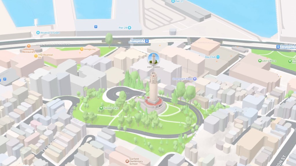
3D Detailed City Experience
Arguably one of the coolest features in Apple Maps, users can switch from 2D to a 3D map of a variety of locations. The Detailed City Experience shows buildings, parks and roads in amazing detail. If you’re feeling adventurous, you can visit famous locations like Big Ben and the Golden Gate Bridge and see them in all their 3D glory.
Guides
Guides are Apple Maps’ in-built articles from a variety of online publications around the world. There are curated guides for food, shopping and activities so you’ll never be bored no matter where you are. Users can also create their own guides to share with friends and family.
Indoor maps
We’ve all been lost inside an airport or shopping centre. Apple Maps takes the anxiety out of being lost inside with their indoor maps feature for airports and shops. With indoor maps you can check which floor you’re on, find out which stores are open, and even find the nearest toilet.

Report an incident
Use Siri to easily report hazards, car crashes, or even speed cameras while driving with the Apple Maps ‘report an incident’ feature. This feature even extends to minor issues including incorrect opening hours or addresses for businesses.
Look Around
With Look Around, users have access to interactive street-level images and maps in 3D and high-resolution. Photos for this feature are taken with seamless transition in mind, meaning you can scout out your next holiday location with ease. Explore almost any city in the World in 3D with this immersive feature.

Let us know what your favourite Apple Maps features are in the comments below.