The Pacific Northwest’s hell is just beginning. After being seared by record heat, the fires arrived with a roar.
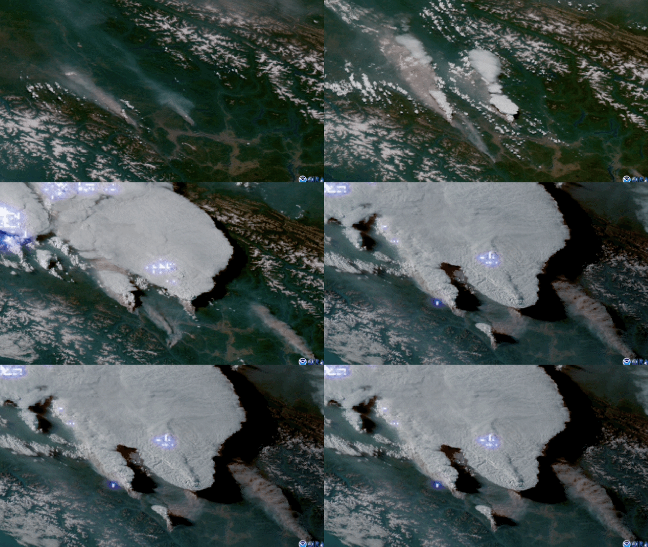
In what is one of the most unprecedented displays of fire weather on record, lightning lit up British Columbia on Wednesday. Satellite data shows a staggering 710,117 lightning bolts — 5% of all of Canada’s lightning in an average year — formed over the province and parts of Alberta. The concentrated display was caused in part by fires already burning on the ground that were so intense, they created their own weather system. The sudden onset means we’re still getting a handle on just what is happening in British Columbia’s forests, but the early signs are not good.
“The potential for things to burn there is extreme if it gets dry enough,” Daniel Swain, a climate scientist at the University of California, Los Angeles, said. “It’s bloody well dry enough. The one thing we were all hoping wouldn’t happen happened. It’s a little hard to wrap the numbers around.”
“I’m being careful about my words. I suspect it will get a lot worse, and it’s already quite bad.”
Things turned for the worse late on Wednesday. Lytton, a town that became famous in the preceding days for breaking Canada’s all-time high temperature three days in a row, burned to the ground. Officials believe it may have been caused by a train, but now firefighters will have to contend with a whole other disaster that’s just beginning to unfold.
Chris Vagasky, a meteorologist and lightning applications manager at Vaisala, said in an email that the 710,117 lightning events captured by satellites included “nearly 113,000 cloud-to-ground strokes.” Some of that lightning was generated by the fires already burning, which created pyrocumulonimbus clouds. Those form when the heat from flames creates powerful updrafts that lift smoke and ash high into the sky. The air cools as it rises tens of thousands of metres above the surface, and all the particulate matter suspended in it acts as magnets for water droplets. They’re essentially frankenclouds that are part smoke, part, uh, cloud that act just like a thunderstorm and shoot lightning across the sky or back to Earth.
That’s what happened on Wednesday at a scale that’s honestly hard to comprehend. The most recent notable example of a lightning-driven firestorm occurred in California last August. But even that’s not really a great analogue; Vagasky noted that, during that storm, “there were about 20,000 cloud-to-ground strokes” over a four-day period — a fraction of what happened in Canada on Wednesday. The heat then was also nowhere near as extreme as what the Pacific Northwest just saw.
Swain said some of the satellite imagery shows the clouds reached heights near 18,288 metres above the Earth’s surface. That allowed them to punch through the tropopause, a boundary that delineates the lower atmosphere from the stratosphere, and pump smoke into the upper atmosphere. This is extremely rarified fire behaviour.
“It essentially looked a lot like a pretty significant volcanic eruption,” Swain said. (If you had wildfires mimicking volcanic eruptions on your climate apocalypse bingo card, congrats, I guess?)
A similar thing happened with the 2019-20 Australian bushfires, and a study released earlier this year found that it warmed the stratosphere for six months. It will require some research about the current fires to see how much smoke ends up in the stratosphere, but what is clear is that we are facing dire impacts for months to come.
British Columbia is relatively less populated than places like California, but its forests are primed to burn. Even before the extreme heat dried things out, the province has dealt with a massive bark beetle outbreak. Rising temperatures driven by the climate crisis have allowed the beetles to be more active. Since the 1990s, 50% of the province’s lodgepole pine trees have been infested, and nearly 18 million hectares of forest have been affected, according to Natural Resources Canada.
That, coupled with steep terrain and tough-to-access land, means fires will have miles to race through the forest uninterrupted. Those in the region could face similarly dangerous conditions to Lytton; the town was overrun by flames in less than an hour, and videos show residents racing past flames and burning structures.
“This is going to affect a bunch of tribal areas and Indigenous lands that don’t have the same relatively minimal level of resources these incorporated towns have in BC,” Swain said. (Lytton’s First Nation community has already started a GoFundMe and you can donate here.) “I don’t want to discount the human impact.”
Swain also noted this could be a major carbon dioxide blast for the atmosphere. The provincial government estimates that the forests store up to 7 billion tonnes of carbon. If they burn, though, that stored carbon becomes carbon dioxide in the atmosphere. Just as the Australian bushfires and Siberian wildfires of recent years have released massive pulses of carbon dioxide, so too could this year’s British Columbia wildfires. It’s an increasingly horrible feedback loop of climate change making wildfires worse and, in turn, wildfires making climate change worse.
The forecast for the coming days doesn’t look good, with widespread warmth continuing in the region. We’re 24 hours into what is shaping up to be a significant event. And while there could be a wild card rainfall even though this is the dry season, it’s unlikely, and that could mean a hot, smoky summer.
“In BC, I would expect most of these fires will burn until the snow falls,” Swain said. “That’s not even a bold prediction. The dryness is off the charts, the number of ignitions is off the charts, the intensity of fires is off the charts.”
