The Suunto Ambit2 (HR) won’t read you your email and doesn’t know Will.i.am’s phone number. But, it will tell you your precise location anywhere on earth and powerfully monitors your physical exertion. How many beers did that climb burn? http://indefinitelywild.gizmodo.com/achieving-hima…
Movescount platform, which is a community for tracking, planning, and sharing your achievements.
The watch is packed into a glass fibre reinforced casing and has a battery life of 24 hours with GPS, so it’s always adventure-ready.
Remember to keep fresh batteries (2032’s) in the heartrate monitor. It won’t do any good, otherwise.
How’s It Supposed To Do It?
The Ambit2’s combination of hardware features, namely GPS, altimeter, and heart rate monitor allow it to calculate a ton of metrics on the fly, giving users data about their distance, location, speed/pace, elevation, heart rate, calorie burn, and more — at a glance.
Its GPS gives the Ambit2 navigational functions, allowing users to navigate by waypoints or routes, create points of interest, save coordinates, and track back.http://indefinitelywild.gizmodo.com/the-time-icela…
The Ambit2 has a FusedAltiTM altimeter, which uses a GPS corrected barometric reading to display a more accurate elevation. Users can choose to display display total ascent/descent, vertical speed, and an altitude graph.
Weather functions feature temperature, sunrise/sunset, a storm alarm, and even tide information.
A digital compass allows users to navigate in more traditional methods when paired with a map, while general functions such as time/dual time, date, and alarm make it incredibly versatile for everyday use.
The Ambit2 uses a proprietary, but well-designed USB cable to sync and charge.
Data is transferred and the watch is charged via an included USB cable. Once plugged in, information from the Ambit2 is automatically synced online with Movescount. There, users can view detailed breakdowns of their activities through the use of interactive charts, bar graphs, and maps.
3,000 calories burned on a “regular day?” No wonder I can’t gain weight.
How Does It Perform?
While the Ambit2 is designed to excel at tracking sports like running, cycling, and swimming, we were primarily interested in testing it in the outdoors. So, we put it to use while trekking and mountaineering in Nepal.
Hardware: Having previously worn only non-GPS watches, the Ambit2 felt huge and bulky (nearly 2″x2″; 0.71″ thick) on my not-so-large wrist. I quickly got used to the size, however; now it feels normal. That being said, its bulk often causes it to snag when taking a backpack on and off; I have to contort my elbow in a weird way to get my arm through the straps.
The construction materials are sturdy. After three months of rugged, continuous use, there are no signs of wear on the rubber strap; no scratches on the mineral crystal lens.http://indefinitelywild.gizmodo.com/goal-zero-sher…
The Ambit2’s battery life is great. Suunto claims 24 hours of GPS use on a single charge. In the real world, that translates to about 4-5 full (winter) days of trekking. When not in GPS mode, the watch is supposed to get 30 days of use on a single charge. In practice, it’s long enough that I can easily forget it’s a rechargeable watch. When the battery does get low, it recharges from USB pretty quickly.
Basic Functions: The basic functionalities of the watch have been incredibly useful while travelling abroad. Local time is displayed big and bold. Dual time allows me to keep PST on the forefront too, so I always know if my peers and colleagues are awake when I need to send emails, submit articles, etc. The alarm clock is loud enough to wake me, even after a short night’s rest; it features a snooze button too. The Ambit2 can show the day of the week in addition to the date. The “view” button can be assigned to a shortcut for quick access. The display can be inverted to offer greater visibility in varying conditions.
The Ambit2 displays graphical representations of your elevation profiles on-the-fly.
Activity Tracking: To begin tracking an activity, press the “start” button. Scroll through the list (activities can be added to or removed from the watch through Movescount) and choose the relevant one. Once you select the activity, the Ambit2 will automatically search for both the heart rate monitor and GPS. Once these are located, you’ll get a signal lock notification and can begin tracking your activity. Even if conditions prevent a GPS lock (for instance, due to heavy cloud cover) you can still start the timer on your activity; once a lock is established GPS tracking will automatically begin.
120 hour recovery time? How about 12? Hike. Eat. Sleep. Repeat.
While tracking, a plethora of information is available on the fly. In trekking mode, the primary view will feature distance, with a small timer on top. The lower part of the display can be cycled through to show other information including pace, speed, elevation, and time. Hitting the “next” button will take you to the altimeter. The lower part of the display here can be cycled through to show total ascent, total descent, or climbing speed. The next display shows an elevation graph. The next: heartrate monitor. Here, you can view your heart beats per minute, calories burned, and Peak Training Effect (PTE.) The final display is the compass.
In climbing mode, most of the information is the same as in trekking mode, but priority is given to the altimeter functions.
All of this information is not only interesting, but it can be incredibly useful for adapting trip itineraries on the fly, and for planning acclimation if venturing into high-altitude country or climbing.
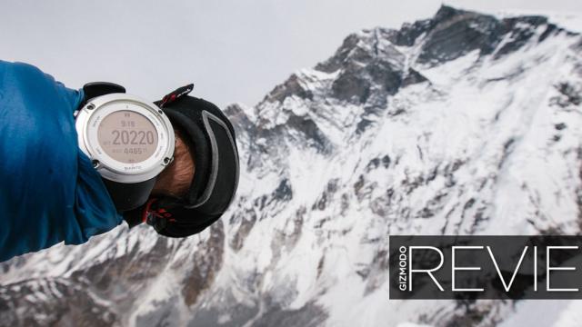
The FusedAltiTM seemed to be pretty accurate, but not perfect. The summit of Island Peak read as 20,220′, when in reality it’s actually 20,305′. While trekking, it was close enough to give you a general idea of where you were at though.http://indefinitelywild.gizmodo.com/beyond-trolltu…
The GPS seemed pretty accurate too, though tracking would sometimes be interrupted in areas with cloud cover; sometimes even when it was clear. On longer days, however, I would notice discrepancies in distance travelled between the Ambit2 and the InReach Explorer, which was simultaneously tracking my treks. The greatest of these I noticed when coming down from the Langtang Valley. The Ambit2 noted my final distance for the day at 16.26 miles, while the InReach Explorer read closer to 20 miles. Some of this distance discrepancy could be attributed to user error (the InReach is always running, while I’ll often pause the Ambit2 when I stop; sometimes don’t remember to turn it back on once I start moving again.)
The need to manually pause the watch when stopping leads me to another point: The Auto-Pause feature on the Ambit 2 just doesn’t work that well while trekking. I imagine that while running, it works great. There’s a big difference between hitting the pavement at a 6 minute/mile pace and waiting for a stoplight. However, when trekking, speed varies greatly depending on the presence of technical features on the trail. Auto-pause would often stop the watch when I was still moving. This was frustrating and threw me off my groove, so I disabled it.
Navigation: I’ve never found GPS navigators all that useful. Instead, I prefer to do things the old-fashioned way: using a detailed topographical map and navigating by natural features and a compass when necessary. Oftentimes, it seems that finding GPX tracks for a particular trek is futile. If you can find GPX tracks, chances are that the trail is heavily-trafficked enough that you won’t need a GPS anyway. As such, I didn’t find this functionality of the watch all that useful for preplanning. However, the ability to set Points of Interest (POIs) could be really useful for marking and navigating back to discoveries in the wilderness.
The compass however is a great feature and in my testing regions, it proved to be very accurate. Zero degrees perfectly centered me on the North Star, allowing me to set up the above shot
23:31 of “Maximal” effort exerted. 3:20 of “Hard;” 1:26 of “Very Hard.” I’d say that’s a good day.
The Ambit2’s hardware is robust, but that’s only half its story. The ability to add apps lends to some powerful adaptability. Additionally, Movescount is a feature-rich, yet easy-to-use platform for discovering more about your activities. There are tons of interactive graphs and charts that provide really detailed statistics from everything to recovery time to Excess Post-exercise Oxygen Consumption (EPOC) Peak, to the highest point reach and distance traveled. All of that information is useful for tracking your fitness and it’s fun to look back on.
The routes from your activities are plotted on Google Maps and the tracks can be exported to a route planner for sharing or future use.
Adventure Ready?
Suunto Ambit2TBAPrice: $499
Like
- Excellent software.
- Ability to add apps.
- Massive range of features.
Don’t Like
- Some sensor inaccuracy.
- Huge, bulky construction.
- GPS drains battery.

The Suunto Ambit2 is a powerful, feature-rich computer-on-your-wrist. Though it’s bulky, it’s well-made. It has a ton of features that make it invaluable for tracking activities in the backcountry; its battery life allows it keep going when previous generations’ GPS watches would long be dead (though, if on longer treks, you’ll still need to carry some kind of recharger in order to utilise the GPS mode every day).
Though there seemed to be some slight inaccuracies in the tracking data, those kinds of things are to be expected when using sensitive electronic gear out in the wilderness. They weren’t enough to cause alarm, and were balanced out by the extreme usefulness of this particular piece of gear. Perhaps best of all, the Ambit2 can be picked up right now for about $US250 – over $US150 off retail, making this watch an incredible value.
About the Author: Chris Brinlee Jr. is an adventurer and storyteller who is currently travelling around the world. Follow his journey on Instagram: @chrisbrinleejr.
Photos: Chris Brinlee, Jr.
IndefinitelyWild is a new publication about adventure travel in the outdoors, the vehicles and gear that get us there and the people we meet along the way. Follow us on Facebook, Twitter, and Instagram.