Using an airborne laser mapping technique called “lidar”, an international team of archaeologists has uncovered an astounding number of previously undetected structures belonging to the ancient Maya civilisation — a discovery that’s changing what we know of this remarkable society.
As difficult as it is to believe, this mapping effort, which is now the single largest lidar survey in the history of Mesoamerican archaeology, revealed the presence of 61,480 distinct ancient structures hidden within the dense tropical rainforests of Guatemala.
“Even though some earlier lidar studies had prepared us for this, just seeing the sheer quantity of ancient structures across the landscape was mind-boggling,” Thomas Garrison, a co-author of the new study and an archaeologist at Ithaca College, told Gizmodo. “I’ve been walking around the jungles of the Maya area for 20 years, but lidar showed me how much I hadn’t seen. There were three to four times as many structures as I had imagined. One site that I work at, El Palmar, is now 40 times larger than we had thought! That’s a totally different kind of place than what we had imaged — and it requires a totally new interpretation.”
This project, the details of which were published today in Science, involved a team of 18 experts from the US, Europe, and Guatemala, and as Garrison points out, it’s providing new insights into ancient lowland Maya civilisation, particularly in regards to its demography, agriculture, and political economy.
Lowland Maya civilisation flourished for nearly 2500 years, starting around 1000 BC and ending with the arrival of Europeans in the 16th century AD. The ancient Maya, whose range extended from what is today southern Mexico, Guatemala, and Belize, were known for their sophisticated architecture, art, writing, astronomy, and maths. At its peak, this civilisation had spread across a territory measuring 95,000km² in size, much of it wetlands.
Today, a sizeable portion of this territory is obscured by rainforest, which is difficult to explore on foot. As a result, there are some gaps in our understanding of ancient Maya societies.
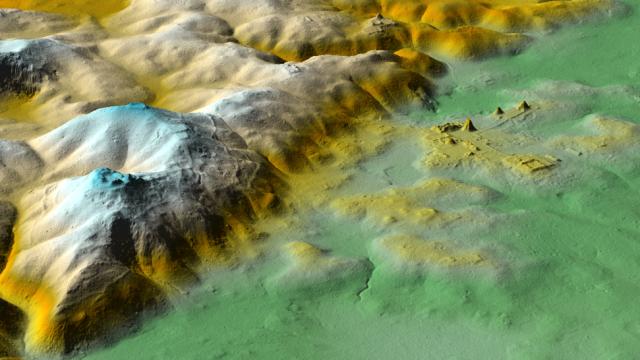
And that’s where lidar can help. This aerial survey technique works by shining pulsed laser light onto a target area and measuring the reflected light with a sensor. Lidar produces a high-resolution, three-dimensional view of the area below, revealing, as in this case, previously unseen surface features.
The lidar survey was done in 2016, and it covered 2144km² of northern Guatemala. The researchers, led by Marcello A. Canuto from Tulane University, mapped a dozen different areas in Petén, Guatemala, acquiring lidar scans of Maya settlements and infrastructure. As noted, the survey resulted in the identification of 61,480 ancient structures, which were further analysed using pre-existing maps previous excavation work.
Importantly, however, many of these sites were also confirmed by ground-truthing (i.e. visually inspecting the sites from the ground) and by conducting new excavations, both of which were done from August to December 2017.
“One of the most exciting structures found was a small pyramid complex right in the heart of downtown Tikal,” said Garrison, “While we still do not know much about this structure, the fact that lidar revealed a new pyramid in one of the most thoroughly mapped and understood cities is incredible and really highlights how powerful this technology is for archaeologists.”
Looking at the lidar data, the researchers estimate that between seven million and 11 million people lived throughout the Maya Lowlands during the Late Classical Period (650 to 800 AD). This ancient population was unevenly distributed across the central lowlands, with varying degrees of urbanisation.
That’s a lot of people, and it likely means that a significant portion of wetlands had to be modified for agricultural use to sustain this population. As the authors write in the study:
Approximately half of the central Lowlands are seasonal wetlands known as bajos. Because permanent settlements tended to avoid these flood-prone and poorly drained areas, they remained largely uninhabited and could then be available, after added investment, to intensive agriculture.
And indeed, of the area scanned, around 1314km² of land was used for agriculture, of which 362km² had to be heavily modified.
The scans also revealed an extensive network of roads (the researchers documented around 106km [106 kilometers] of causeways), which connected cities and towns. Many of these urban centres were heavily fortified, which wasn’t expected.
“The causeway networks that we see reflect an earlier time for the Maya — what we call Preclassic — when cities were linked by long roads running through the jungle landscape,” said Garrison. “In the Classic period, the Maya were divided into dozens of competing city-states, each with their own local dynasty. It seems that part of maintaining these kingdoms involved investments in substantial infrastructure projects to integrate the population (internal causeways), feed the people (extensive field systems), and protect the kingdom (defensive earthworks).”
Indeed, the Maya did engage in warfare from time to time. Garrison says their own written accounts provide vivid descriptions of war, in one case using hurricanes as a metaphor for the fury of war and, in another describing its aftermath as the “piling of skulls and the pooling of blood.” Archaeologists also had knowledge of some defensive earthworks at sites like Tikal, and even at strategic landscape points in the western Maya area.
But the new lidar data is showing that these features were far more common than archaeologists had imagined, reflecting a previously unconsidered level of militarisation.
“As an example, I work at the small kingdom of El Zotz, the closest city to Tikal. Lidar revealed an actual fortress on an escarpment edge between these two cities,” Garrison told Gizmodo. “The citadel is protected by walls that are over 7.62m tall, and there is a large artificial reservoir that looks like an Olympic swimming pool. In other words, this place, named La Cuernavilla, was ready for a siege. That is not really the type of conflict that we think about for the ancient Maya.”
Garrison admits that lidar isn’t perfect, and that it misses some things and occasionally makes natural features appear artificial. Overall, however, he feels “this is an almost complete footprint of the ancient Maya.” Which brings up another limitation.
“These images represent the entire duration of the ancient Maya civilisation. It’s over 2000 years compressed into the images you are seeing,” he said. “Not everything was occupied all at the same time, and it is now our job as archaeologists to sort all of this out. But we’re certainly happy to have these new problems!”
[Science]