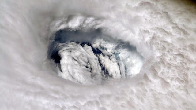
Hurricane Dorian landed in the Bahamas with unprecedented ferocity this weekend. At its peak, the storm lashed the Abacos Islands and Grand Bahama with sustained winds of 298km/h, making it the strongest storm to ever hit the island nation and one of the strongest to ever form in the Atlantic.
All of that would be bad enough except Dorian’s forward progress ground to a halt, blasting the islands for hours on end as it crawled forward at an excruciating 2km/h at times throughout the weekend and into this week. That’s largely due to steering currents in the atmosphere breaking down, leaving Dorian to meander.
The crawl has continued into Wednesday, though there are some signs the storm will pick up speed again and begin its northward turn. And in a strange twist, Dorian may help fuel weather patterns hundreds of kilometres away that will, in turn, steer the storm as it inches nearer to the Southeast United States.
The atmosphere is a messy, chaotic place. Winds whip in different directions at different heights thousands of feet above the Earth’s surface. Huge blobs of high pressure can steer those winds in certain directions. Hurricanes and the tracks they take are a product of all these forces.
Various winds and pressure systems guided Dorian through the Caribbean and its “hurricane graveyard” into the Atlantic last week. And then just as Dorian headed toward the Bahamas, it’s like someone pulled the plug on the atmosphere. The winds that were guiding the hurricane west sputtered to a halt, causing the storm to basically come to a standstill over the Bahamas.
“Think of Dorian as a leaf in a stream,” Jack Sillin, a forecaster with weather.us, told Gizmodo in a Twitter DM. “When the water in the stream stops moving, so too will the leaf. Unfortunately for the Bahamas, Dorian has been stuck without any steering currents for the last couple days, resulting in its very slow/nonexistent movement.”
Dorian itself has also contributed to some of the bigger weather patterns causing it to hunker down. Hurricanes feed on warm ocean waters to gain strength. As they lift up seawater, it condenses and even freezes in the cooler upper atmosphere. That process releases heat, and in Dorian’s case, that heat has helped fuel a high-pressure system that’s slowing it down.
“All this hot air near the top of the atmosphere needs to go somewhere, and some of it has been moving north into the ridge over North Carolina,” Sillin said. “This added heat has helped to strengthen the ridge, which is part of the reason why the storm hasn’t started moving north yet. Thankfully, this effect is very unlikely to change the storm’s track, and the centre is still expected to remain east of the Florida coast.”
These types of stalling hurricanes have become more common in recent decades, according to recent research conducted by NASA and U.S. National Oceanic and Atmospheric Administration scientists.
While the research doesn’t lay out a specific mechanism for why Atlantic hurricanes may be stalling out more frequently, climate change is one possibility. Specifically, the researchers point to rapid warming in the Arctic and its impact on the jet stream — namely that it’s made the rapidly moving river of air more wavy and sluggish, upending a major weather driver — as one potential reason. (It’s still a very active area of research.)
In Dorian’s case, the stalling that allowed it to rake the Bahamas all weekend with powerful winds and deadly storm surge. Kristen Corbosiero, a tropical cyclone expert at the University of Albany, told Gizmodo the stall was likely more due to high pressure boxing the storm in, though she called the paper’s result “staggering” and something researchers and coastal residents should keep an eye on in the coming years as the planet keeps warming.
The storm has finally moved away from the island nation and begun a (still-sluggish) turn to the northwest. It should begin to pick up speed in the coming days as steering currents once again develop. Interestingly, the storm itself could contribute to those steering currents.
The latest update from the National Hurricane Centre indicates that Dorian has winds of 177km/h — a still-potent Category 2 storm with a growing wind field — and will march up Florida’s east coast likely without making landfall there.
Corbosiero said the movement of a trough of low pressure coming out of the Rockies over the next few days will dictate if the storm eventually makes landfall in the Carolinas by Thursday or Friday. If the trough moves quickly out of the Rockies eastward, it could sweep the storm out to sea, but a slower movement could allow Dorian the chance to hook into the Carolines.
Regardless, landfall isn’t necessary for the storm to have an impact. It simply means the eye of Dorian — where the storm’s winds are strongest — won’t come ashore.
Much of Florida’s east coast along with coastal Georgia and the Carolinas are still forecast to contend with the outer bands of Dorian’s hurricane-force winds, up to 38 centimetres of rain, and powerful storm surge and surf.
Coastal waters could rise up to two metres above ground from northern Florida to North Carolina if the surge arrives at high tide.
