The impacts of the record-breaking Pacific Northwest heat wave are still playing out across the region. Medical offices are still getting a handle on the loss of life, and firefighters are battling a number of massive wildfires across the region.
Now, satellite imagery makes clear another terrible impact: The region’s snow and ice took a massive hit. Hotter-than-normal temperatures on high accompanied blistering triple-digit heat in the valleys, and snowpack shriveled as a result. The European Space Agency’s Sentinel-2 satellite passed over the region before and after the heat wave. The imagery from the Olympic Peninsula to the iconic volcanoes like Mount Hood and Rainier shows the disappearing act of the ice and snow.
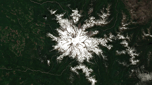
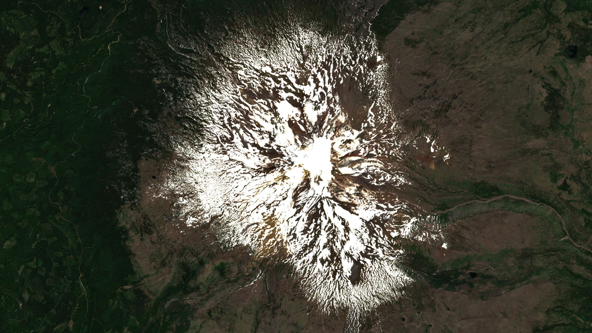
Reports earlier this week indicate Mount Rainier lost 30% of its snowpack in the heat wave alone. Even before then, the 254 centimetres or so of snow on the ground at the Paradise weather station was in trouble. The heat wave basically just turbocharged the decline.
“I don’t recall 100 inches of snowmelt, basically, [240 centimetres] of snow occurring over a 21-day period,” Robert Hahn, an avalanche meteorologist for the Northwest Avalanche Centre, told local station KOMO.
What that means for the region’s glaciers is an important question. The climate crisis has already put those glaciers on a path of decline. Later this month, researchers will conduct their 38th year of observations in the North Cascades to see how the ice fared from the heat wave. The imagery from not just that region but across the Northwest tells a dark story.
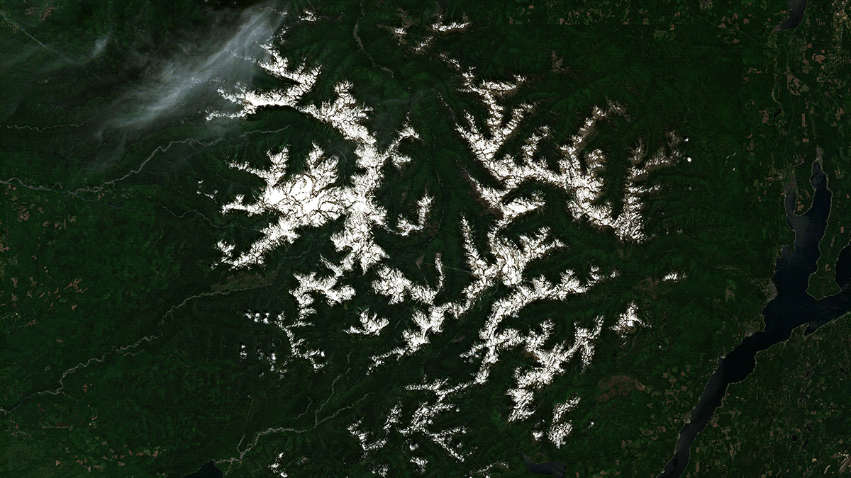
North Cascades
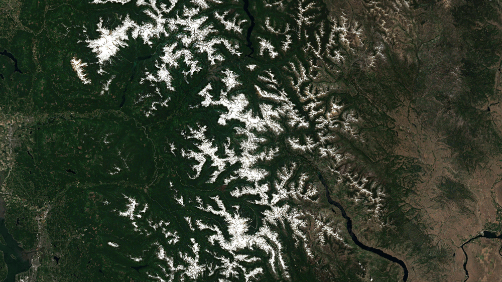
The North Cascades sit in Washington and run right up against the U.S.–Canadian border. The glaciers are an important source of water for farmers and residents. (The same is true for glaciers that dot the entire Cascade range, which runs from California to British Columbia.) In fact, the long, snake-like Lake Chelan visible in the lower part of the picture above provides drinking water for an entire district. Overall, the North Cascades glaciers provide a quarter of the region’s water supply in summer.
The glaciers and snow are also big when it comes to recreation; North Cascades National Park’s roughly 300 glaciers bring hikers and mountaineers from around the world. Mauri Pelto, the head of the North Cascades Glacier Climate Project and vice president for academic affairs at Nichols College, is leading a team into the field to see how the ice is doing this year, particularly in the wake of the heat wave. The biggest concern is what the heat wave did to the snow, which normally acts as insulation for the glacial ice underneath.
“For us, the most important thing is just really having an assessment of how much of the glacier is bare ice,” Pelto said. “[This] is really crucial because if you think back to 2015, the real problem for those glaciers was that they were essentially mostly bare ice by August 1. Ice melts, 30% to 40% faster in the same place snow would.”
Back in 2015, the region saw a major heat wave in early July. This year’s heat wave, though, was even more extreme. That doesn’t bode well for the snow.
The image above gives a sense of the scope of the snow’s disappearance (as well as the appearance of a wildfire, one of hundreds raging throughout the region).
Mount Hood
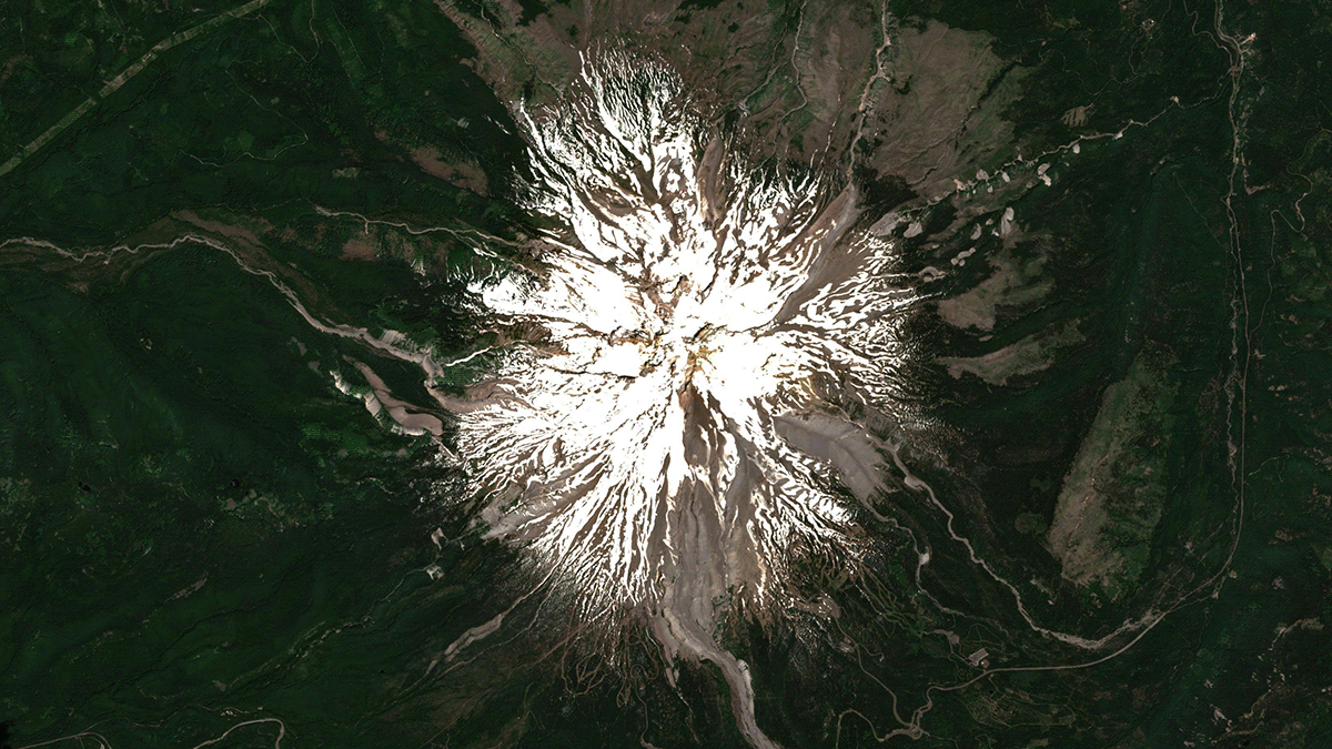
The North Cascades are relatively lower in elevation than the region’s high peaks. But the impacts of the heat on those peaks is no less dramatic. Mount Hood, the tallest mountain in Oregon, saw the snowline rapidly recede uphill during the heat wave. Normally snow-clogged gullies have dried out.
The snow melted out so fast, campers were forced to evacuate from area campgrounds as rivers and creeks filled up. The deluge of water means that there’s less left for the remainder of the summer dry season.
Mount Saint Helens
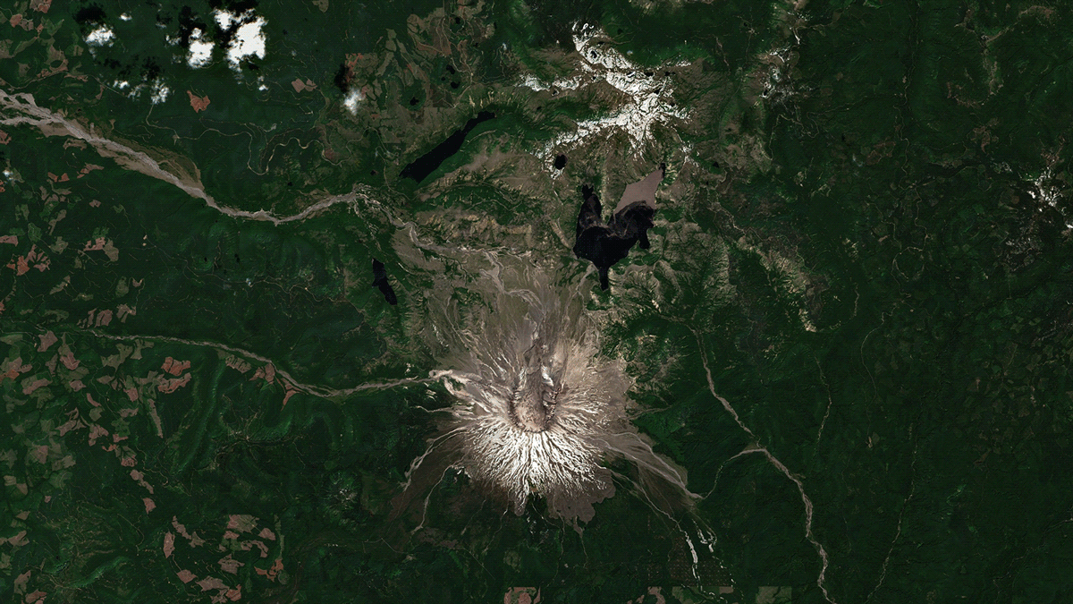
Of the major peaks in the Cascades, Mount Saint Helens is one of the lower ones. The 1980 eruption caused the mountain to lose 396 metres in elevation. The eruption also destroyed most of the mountain’s glaciers, though a new one did form inside the crater at the summit. The mountain has considerably less snow than its taller, more heavily glaciated cousins. But the disappearance is still shocking to see.
Mount Adams
Mount Adams sits just to the east of Mount Saint Helens. It’s high enough to support glaciers, including a number located in cirques or steep valleys carved by ice. Similar glaciers exist across the North Cascades, and Pelto said he’s curious to assess how those glaciers are doing.
That’s because those glaciers rely not just on direct snowfall but also frequent avalanches that can help them gain mass. That’s particularly true for ones that are lower in elevation where snow is more marginal and melt season starts sooner. Pelto said a colleague visited Columbia Glacier in North Cascades in June and reported that avalanches had served the glacier well over the winter. What the heat wave did, though, remains to be seen.
The freak heat, which was made 150 times more likely due to climate change, isn’t the only risk to those glaciers. In fact, climate change could be causing other issues for them as well. Less snowfall could make avalanches less likely, further speeding glaciers’ demise.
“As the climate changes, are those slopes, are the pockets [in them] harder to fill?” Pelto said. “It’s not straightforward, but on the Columbia, we’ve really seen that it takes a lot more snow to fill up the pockets. They used to have little niche glaciers. And so avalanching doesn’t happen as easily.”
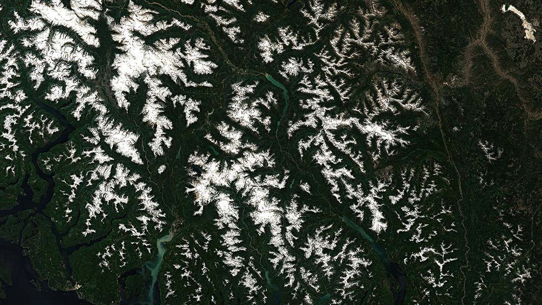
Olympic National Park
Snowpack shrinking in summer is the norm. But Pelto noted that the heat wave dramatically sped up the process. In the North Cascades, snowpack was actually relatively healthy for late June. But the heat wave changed the equation.
“Normally, July 4, the places are totally still covered,” Pelto said. “And then during July, depending on which place you are, you get a little bit of ice exposure. This just sped up that process by two weeks, essentially. We went from one where we had more snow than usual by a few days to where, all of a sudden, we jump to mid-July conditions by the first of July, just in those few days.”
The same jump step is visible in other mountain ranges in the region, too. That includes the peaks of Olympic National Park. The snow disappeared in the high peaks while locations in the normally temperate rainforest that grace the west side of the park cracked triple digits and easily set all-time records. Elsewhere, shellfish that populate the region’s waterways cooked en masse.
Garibaldi Provincial Park
There’s perhaps no more perfectly terrible distillation of the heat wave’s impact than the final satellite image, which shows the disappearing snow in British Columbia’s Garibaldi Provincial Park, the northern end of the line for the Cascades, and wildfires igniting to the park’s east. The extreme heat coupled with a slew of lightning ignited the tinderbox that was interior British Columbia. Firefighters are grappling with at least 300 fires.
Of course, this is also far from a regional story. The world’s ice is disappearing at an alarming rate from Antarctica to Everest. Fires, too, are becoming more intense and frequent. These problems are intertwined with the climate crisis, driven by fossil fuels and carbon pollution. that’s making these conditions increasingly the norm. While we may see some years here and there that offer a respite, the long-term trend is one that urgently tells us we need to change course or suffer even worse consequences.
“A good winter is not enough anymore,” Pelto said of the snowfall needed to sustain glaciers. “If you look at the overall pattern, the story is very similar to the mass loss for alpine glaciers around the world.”