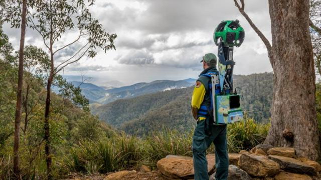
So it turns out Google Street View isn’t just for, well, streets. I just found out it has also been used to capture a whole heap of walking tracks in NSW National Parks.
According to the NSW National Parks website, it partnered with Google to capture imagery from over 50 national parks across the state. It did this using a specialised backpack-mounted trekker, which came back with 1,350km worth of footage.
This isn’t a new feature, but it’s certainly news to me. And as an avid hiker I think it’s great. Not only does it allow people to virtually explore these beautiful spaces from home, it’s a perfect planning tool.
For example, if you wanted to check out a walk or a the realities of a camping spot before hitting the trail, you can.
[related_content first=”1196389″]
If you’re interested in taking a peek yourself, here’s a big list of some of the NSW National Parks walks you can check out in Google Street View
Sydney and Surrounds
- Aboriginal Heritage walk in Ku-ring-gai Chase National Park
- Bouddi Coastal walk in Bouddi National Park
- Bradleys Head to Chowder Bay walking track in Sydney Harbour National Park
- Cliff Top walking track in Blue Mountains National Park
- Henry Head walking track in Kamay Botany Bay National Park
- O’Hares Creek lookout in Dharawal National Park
- The Coast track in Royal National Park
North Coast NSW
- Barrington trail in Barrington Tops National Park
- Cape Byron walking track in Cape Byron State Conservation Area
- Crowdy Gap campground in Crowdy Bay National Park
- Pinnacle walk and lookout in Border Ranges National Park
- Tomaree Head summit walk in Tomaree National Park
- Sea Acres Boardwalk in Sea Acres National Park
- Yuraygir coastal walk in Yuraygir National Park
South Coast NSW
- Light to Light walk in Ben Boyd National Park
- Montague Island walking track in Montague Island Nature Reserve
- Pigeon House Mountain Didthul walking track in Morton National Park
- Pretty Beach to Snake Bay walking track in Murramarang National Park
- Robertson lookout in Illawarra Escarpment State Conservation Area
- White Sands walk and Scribbly Gum track in Jervis Bay National Park
Country NSW
- Belougery Split Rock walking track in Warrumbungle National Park
- Breadknife and Grand High Tops walking track in Warrumbungle National Park
- Kanangra Boyd lookout in Kanangra-Boyd National Park
- The Lookdown lookout in Bungonia National Park
- West Rim walking track in Morton National Park
Snowy Mountains- Kosciuszko National Park
- Jillabenan Cave at Yarrangobilly Caves
- Kosciuszko walk – Thredbo to Mount Kosciuszko
- Mount Kosciuszko summit walk
- Perisher
- Snow Gums Boardwalk
- South Glory Cave at Yarrangobilly Caves
- Thredbo Alpine Village
Outback NSW and Murray-Riverina
- Mungo self-guided drive tour in Mungo National Park
- Valley of the Eagles walk in Gundabooka National Park
- Walls of China in Mungo National Park